Kartensoftware
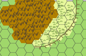
Die Kartensoftware Hexographer, welche Karten im Hexfeld-Design erstellt hat ein neues Update erfahren. Das entscheidende an diesem Update ist das die Software nunmehr nicht nur Flächen als aneinanderreihung von Waben darstellen kann sondern die Flächen auch als Bezierkurven wie üblich gezogen werden können um darauf dann ein Hexfeld zu legen. im Deatil sieht das dann so aus:


Desweiteren ist zu erfahren:
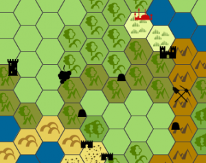
There are a slew of fairly major changes in the newly updated version of Hexographer. The theme of this release is „breaking out of the hex“ because two of the most important changes allow you to place terrain and features independent of the hex. A feature icon (castle/city/cave/etc.) doesn’t have to be in the center of the hex and you can even have many in a hex and you can scale the icons down in size (or up if you have a reason to) in case you want to show a couple feature near each other or represent their significance, etc. Likewise terrain can be placed independent of a hex and you can also place individual terrain icons (no background) in case you want to show denser mountains, a thicker forest, etc. See the samples below for an example of these features.
Here’s a fuller list:
* You can place a dot in the center of your hexes to more easily measure sight-lines. Go the the „Show/Hide“ menu and look for the „Dot in Hex Center“ menu item.
* Elevation/plateau lines will now have hash marks on one side. You’ll be able to designate the line style as „hashed“ just like you do „solid line“ vs. „dotted line“ vs. „dashed line“ on custom lines. Styled lines can use the new line type through the „Line/Text Settings“ window from the „Options“ menu. And you can toggle which side of each line gets the hashes.
* Features can now be placed in ways that break the one-to-one relationship to a hex. You can snap them to preset points of a hex or just place them freeform. This allows you to place the feature icons a little more precisely. Go to the „Options“ menu and check one of the „Feature Placement“ options to change the feature placement.
* Related to feature placement, you can scale down (or up) the icon size of a feature. This allows you to place two icons nearer eachother, make less important features smaller, etc.
* You can likewise add terrain independent of hexes. You can place terrain as before(one to one), or place it independent of hexes, or place just extra terrain icons independently of the hexes. For example, you can create a mountain range where the hexes don’t match the hex grid overlay and then add in extra mountain icons to make it more dense looking.
* Related to the feature and terrain placement options, you can now delete terrain and features. This was needed to delete terrain or features that aren’t tied to specific hexes. In the past when terrain and features were one-to-one with a hex you could simply overwrite the terrain in a hex and it would cause the terrain to change and the feature to also be removed. This still works for terrain and features that are placed in the one-to-one style.
* Four new terrain types were added, but in a slightly different style. The terrain types are forest, mountains, badlands, and wheat fields. These are used in games like „Settlers of Catan“ and allow the tool to be used to create maps for „Settlers of Catan“ or other games in similar styles. The older forest, mountains, and cultivated farmland icons weren’t a good fit, but the existing plain farmland could be used for the sheep fields. (The older forest, mountains and cultivated farmland icons are still in the tool because they are ideal for classic RPG maps.)
* A number of typos were corrected in the instructions and the instruction dialogs were made a little prettier.
* Many map items have sample icons in the drop down map item selector.
* The opening screen was updated to match the new logo and look of the website. The version number and Java version number are listed on the bottom.
* The file format was changed. Although the file format isn’t designed to be used by others, I know a few people have expressed interest and I’ve given them a description of it. If you are doing something with the raw .hxm file, please note that features now are not on the same line as the matching hex because a hex may have more than one. Any features in a hex are listed on the lines immediately after that hex’s terrain entry. I can go into more detail if asked.
* In case there are major issues, the prior version is still available. The prior free version is linked on the bottom of the Free version’s page and the prior pro version is linked on the bottom of the download page. (A link sent to pro users.) Note that the prior version will not read maps that were created or edited in the new version You may want to create a backup first.
Der Hexographer ist erhältlich in drei Versionen:
Als kostenloses Online-Tool
Als Lizenz für ein Jahr für $9.90
Als Vollversion für $28.75
Links:

